Aspatial segregation: Difference between revisions
(Creating page) |
(Creating page) |
||
| Line 12: | Line 12: | ||
[[File:aspatial_segregation.png|780x780px]] | [[File:aspatial_segregation.png|780x780px]] | ||
Visualization based on the [[How_to_cite_Segregation_Wiki| research]] | |||
For the complete network of associated segregation forms, see: | For the complete network of associated segregation forms, see: | ||
year of publication https://tinyurl.com/2235lkhw | * First year of publication https://tinyurl.com/2235lkhw | ||
Louvain clusters https://tinyurl.com/2d8wg5n3 | * Louvain clusters https://tinyurl.com/2d8wg5n3 | ||
* Betweenness centrality https://tinyurl.com/223udk5r | |||
* Disciplines where segregation forms first appeared https://tinyurl.com/244d8unz | |||
==References== | ==References== | ||
==Notes== | ==Notes== | ||
Revision as of 13:40, 3 October 2024
Date and country of first publication[1]
2008
United States
Definition
Aspatial segregation refers to the social and economic division of people along lines of race, class, or other factors, without a physical separation or geographic boundary. This type of segregation can still have a powerful impact on the opportunities and resources available to different groups of people, creating disparities in wealth, education, employment, and other areas of life. Examples of aspatial segregation can be seen in neighborhoods, schools, workplaces, and other community settings where certain groups of people are marginalized or excluded from full participation and access to resources.
See also
Related segregation forms
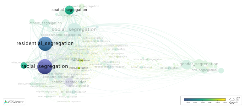
Aspatial segregation is frequently discussed in the literature with the following segregation forms:
residential segregation, racial segregation, racial residential segregation, metropolitan racial segregation, micro segregation, spatial segregation

Visualization based on the research
For the complete network of associated segregation forms, see:
- First year of publication https://tinyurl.com/2235lkhw
- Louvain clusters https://tinyurl.com/2d8wg5n3
- Betweenness centrality https://tinyurl.com/223udk5r
- Disciplines where segregation forms first appeared https://tinyurl.com/244d8unz
References
Notes
- ↑ Date and country of first publication as informed by the Scopus database (December 2023).
At its current state, this definition has been generated by a Large Language Model (LLM) so far without review by an independent researcher or a member of the curating team of segregation experts that keep the Segregation Wiki online. While we strive for accuracy, we cannot guarantee its reliability, completeness and timeliness. Please use this content with caution and verify information as needed. Also, feel free to improve on the definition as you see fit, including the use of references and other informational resources. We value your input in enhancing the quality and accuracy of the definitions of segregation forms collectively offered in the Segregation Wiki ©.
Aspatial segregation appears in the following literature
Reardon S.F., Matthews S.A., O'Sullivan D., Lee B.A., Firebaugh G., Farrell C.R., Bischoff K. (2008). The geographic scale of metropolitan racial segregation. Demography, 45(3), 489-514. Duke University Press.https://doi.org/10.1353/dem.0.0019
Cortes R.X., Rey S., Knaap E., Wolf L.J. (202). An open source framework for non spatial and spatial segregation measures: the PySAL segregation module. Journal of Computational Social Science, 3(1), 135-166. Springer.https://doi.org/10.1007/s42001-019-00059-3
